|
March 10, 2001
Setting the Nuclear Stage and Protecting Yourself
Dear Building Community Family,
- God help us, we've come a long way from this blast to even deadlier capabilities.
|
|
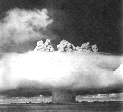
1946 saw Operation Crossroads demonstrate to the public the first atomic explosion since it dropped the bomb on Nagasaki.
|
|
For many of us, war of this proportion takes on a sense of "Hollywood". We see explosions in movies, pyrotechnics dazzle the eye and tweak the adrenaline, and heroes generally emerge unscathed. Bruce Willis of Die Hard fame, "proves" you can beat the odds where ordinary mortals would have been dead five times over. Rarely does the possibility of a war, let alone a nuclear war - on our own soil - seem likely. May it only remain in our nightmares!
Yet after WWII, we continued the pursuit of nuclear weapons and have them refined to the point where they fit in a "suitcase".
|

Pictured Above: U-K Grable detonation on May 25, 1953, Nevada Test Site. Tests were conducted March 17 - June 4, 1953. |
SUITCASE NUKES
Steve Croft, correspondent for 60 Minutes, reported disturbing news during a September 7, 1997 segment. While in Russia, Croft spoke with General Letved, their National Security chief, who revealed Russia had manufactured about 200 suitcase bombs and that approximately 100 of these nukes were missing. Letved indicated each bomb is small

|
enough to be carried by a single person and produce a blast "equivalent to 1,000 tons of TNT, or about 500 times more than the largest conventional bomb used in WW-II, plus massive radiation. He estimated that if just one were exploded by a terrorist in a crowded city, up to 100,000 humans would die."1 The question is, who has these 100 missing suitcase nukes now?
Strong speculation points to two possible candidates, Osama bin
Laden and possibly the Aum Shinrikyo cult, but who has the rest? |
August 20th, 2000, Messianic Rabbi Michael Rood while speaking
in Greensboro, North Carolina quoted an intelligence source close
to the peace process. Rood claimed Yassir Arafat's Palestinian
forces had purchased three suitcase nukes on the black market.
Rood, who runs New Moon Publishing of Two Harbors, Minnesota,
believes the devices are being used as part of a high-stakes gamble
intended to coerce Israel into ceding a portion of Jerusalem to
the Palestinians.2
NUCLEAR FANTASY?
In view of bin Laden's February 1998 fatwa directing Muslims worldwide to kill all U.S. citizens and their
allies, wherever and whenever possible, does this elevate your
comfort zone regarding nukes?
There are possible, though hopefully less probable scenarios,
where a computer malfunctions and a missile-bearing bomb is launched.
That being said, a number of fail-safes have been installed to
ensure this does not happen though we have all seen movie plots
where Russia thinks we have shot off a missile aimed at their
real estate and they send us reciprocal greetings. In addition
to current global tensions, countless people around the world
are having dream/visions of nuclear war events transpiring in
the near future.
With that in mind, we will look at some practical information
that will give us the best possible chances for the least possible
injuries and the most probable areas of concern: shelter, food
and water. We strongly encourage you to read Bruce Beach's You Will Survive Doomsday for more information, as we will hit on the highlights.
What is the likelihood that your particular town or locale will
be targeted? If you live in or around one of the 120 Cities Most
at Risk, the odds go up. (See Part 1 of this series for the list.) Living close to military installations also increases risk. Major airports and railroad passes in and
around mountains and crossing bodies of water or ravines may attract
a terrorist's twitchy fingers. The map below shows the general
location of publicly known military bases. Look on your local
road atlas for airport and railroad information.
PUBLICLY KNOWN MILITARY BASES
 |
WHAT'S TARGETED IN YOUR STATE?
You can also visit Bruce Beach's site and see what nuclear targets are shown for any state. These FEMA
maps are approximately 10 years old, but the majority of information
is the same. You can compare the information to the current map
above.
It might also be clever to factor in U.S. nuclear plant locations in your area. For Canada, go to this page. For the rest of the world, see this page for a very general map. It is less likely a terrorist would send
a nuke to destroy a nuclear facility simply because it would "waste"
the warhead when a reactor already holds sufficient radioactive
material to be lethal many times over. However, this does not
prevent a person or group from using any type of explosive device
ultimately unleashing this radiation.
It is not possible to suggest conclusively what is a safe distance to be upwind of a nuclear reactor accident
or nuclear bomb blast, but at least 50 miles (80 km) would be
clever. Factors such as prevailing wind, size of bomb, etc. would
have to be considered. Suffice it to say, the further the better.
MAP A BLAST
To gain a further understanding how a nuclear blast can spread
radiation, you can plot a detonation from the Blast Mapper in three simple steps. Select whether you want to plot the fallout
from a 1 Mt (megaton) bomb or choose to plot pressure damage from
a 1 Mt or 25 Mt surface blast. Choose what location to plot and
then hit "detonate". Here are a couple of sample blows for two
random cities. The plots on the left indicate the range of fallout
and the two on the right indicate what type of damage would be
sustained from a one megaton bomb. Since the 25 megaton blast
is so massive and less likely, these were not plotted though you
can do so on the Blast Mapper site.
Probable Fallout From a 1 Mt Blast,
Perth, Western Australia
|
Pressure Damage From a 1 Mt Blast,
Perth, Western Australia
|
 |
 |
Probable Fallout From a 1 Mt Blast,
Los Angeles
|
Pressure Damage From a 1 Mt Blast,
Los Angeles
|
 |
 |
|
Assumptions
Key For Above Maps
3,000 Rem* - Distance: 30 miles
Much more than a lethal dose of radiation. Death can occur within
hours of exposure. About 10 years will need to pass before levels
of radioactivity in this area drop low enough to be considered
safe, by U.S. peacetime standards.
900 Rem - Distance: 90 miles
A lethal dose of radiation. Death occurs in 2 - 14 days.
300 Rem - Distance: 160 miles
Causes extensive internal damage, including harm to nerve cells
and cells that line the digestive tract. Also results in a loss
of white blood cells and temporary hair loss.
90 Rem - Distance: 250 miles
No immediate harmful effects, but does result in a temporary decrease
in white blood cells. Two to three years will need to pass before
radioactivity levels in this area drop low enough to be considered
safe, by U.S. peacetime standards.
*Rem: Stands for "Roentgen Equivalent Man." It is a measurement used to quantify the amount of radiation
that will produce certain biological effects.
NOTE: This information is drawn mainly from "The Effects of Nuclear
War" (Washington: Office of Technology Assessment, Congress of
the United States, 1979). The zones of destruction mapped out
on this page are broad generalizations and do not take into account
factors such as weather and geography.
|
Key For Above Maps
12 psi (pounds per sq. in.) - Radius: 1.7 mi. (2.7 km) [Note: The outside edge of this shaded area represents the 12
psi ring. Blast pressure within ring is greater than 12 psi; blast
pressure outside ring is less than 12 psi.]
At the center is a crater 200 ft. deep (61 m), 1000 ft. (305 m)
in diameter. The rim is 1,000 ft. wide, composed of highly radioactive
soil and debris. Nothing recognizable remains within about 3,200
ft. (975 m) from the center, except some buildings' foundations.
At 1.7 miles (2.7 km), only the strongest buildings made of reinforced,
poured concrete are standing. 98% of the population in this area
are dead.
5 psi - Radius: 2.7 miles
Virtually everything is destroyed between the 12 and 5 psi rings.
Walls of typical multi-story buildings have been completely blown
out. The bare, structural skeletons of buildings rise above the
debris as you approach the 5 psi ring. Single-family residences
have been completely blown away except their founda-tions. 50%
of the population between the 12 and 5 psi rings are dead; 40%
are injured.
2 psi - Radius: 4.7 miles
Single-family residences which have not been completely destroyed
are heavily damaged. Office building windows have been blown away,
plus some walls. Everything on these buildings' upper floors,
including the people who were working there, are thrown onto the
street. Substantial debris clutters the entire area. 5% of the
population between the 5 and 2 psi rings are dead; 45% are injured.
1 psi - Radius: 7.4 miles
Residences moderately damaged. Commercial buildings show minimal
damage. 25% of population between the 2 and 1 psi rings have been
injured, mainly by flying glass and debris. Many others have been
injured from thermal radiation -- the heat generated by the blast.
The remaining 75% are unhurt.
|
Continue
© Text and Graphics, 2001 Stan and Holly Deyo, except where otherwise
noted
|